Shira Route
The Shira Route is one of the original routes that approaches from the West.
The Shira Route is nearly identical to the newer Lemosho route. However, it begins at a higher altitude. The unique thing about this route is that instead of walking from a starting gate, a vehicle transfers the group to a high altitude plateau. The road is only accessible by 4-wheel-drive vehicles and can become impassable during wet periods.
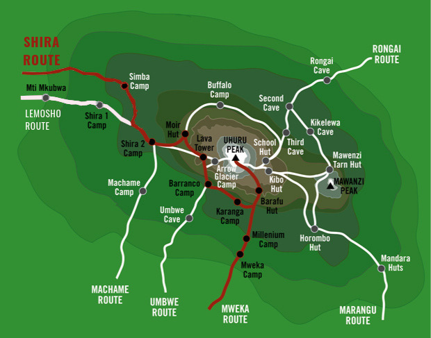
Shira and Lemosho (6-8 days each) both run from west to east across the center of the Shira Plateau. Hikers who embark on this trail begin their trek above the forest in the moorland zone. The Lemosho Route improves on the Shira Plateau Route by starting below the Shira Ridge, thus providing trekkers with a hike in the forest at the beginning of the trek, allowing more time to acclimatize. As with the Shira Plateau Route, you ascend Kibo either by the Western Breach or by the Barafu Route. Descent is via the Mweka Route.
Personally, I would recommend the Lemosho Route over the Shira Route due to the additional acclimatization day and the beautiful rainforest trek at the start.
The Shira Route is not recommended.
DAY 1: SHIRA GATE TO SIMBA CAMP
Hiking Time: 1-2 hours
Total Distance: 4km/2 miles
Starting Elevation: 3,596m/11,800ft
Final Elevation: 3,596m/11,800ft
Habitat: Heath
Depart Moshi for Londorossi Gate, about a 4-hour drive; here we will complete entry formalities while guides and porters prepare equipment. Then continue to drive up a steep path to the Shira Gate where the hike begins. The trek starts through shrubs and giant heather until we reach Simba Camp.
DAY 2: SIMBA CAMP TO SHIRA 2 CAMP
Hiking Time: 2 hours
Total Distance: 6km/4 miles
Starting Elevation: 3,596m/11,800ft
Final Elevation: 3,810m/12,500ft
Habitat: Heath
Today is a fairly easy day to help with acclimatization. You will begin by exploring the grassy moorland and volcanic rock formations on the plateau. Then a scenic path to the Shira Cathedral, a huge buttress of rock surrounded by steep spires and pinnacles, before settling at Shira 2 Camp.
DAY 3 : SHIRA 2 CAMP TO LAVA TOWER
Hiking Time: 4-5 hours
Total Distance: 7km/4 miles
Starting Elevation: 3,810m/12,500ft
Final Elevation: 4,629m/15,190ft
Habitat: Alpine Desert
Lava Tower to Barranco Camp
Hiking Time: 2-3 hours
Total Distance: 3km/2 miles
Starting Elevation: 4,629m/15,190ft
Final Elevation: 3,975m/13,044ft
Habitat: Alpine Desert
The trial continues to the east up a ridge and then head southeast towards the Lava Tower – a 300 ft tall volcanic rock formation. Then descend down to Barranco Camp through the strange but beautiful Senecio Forest to an altitude of 13,000 ft. Although you begin and end the day at the same elevation, the time spent at higher altitude is very beneficial for acclimatization.
DAY 4 : BARRANCO CAMP TO KARANGA CAMP
Hiking Time: 4-5 hours
Total Distance: 5km/3 miles
Starting Elevation: 3,975m/13,044ft
Final Elevation: 3,994m/13,10ft
Habitat: Alpine Desert
The days begins by descending into a ravine to the base of the Great Barranco Wall. Then climb the non-technical but steep, nearly 900 ft cliff. From the top of the Barranco Wall crossing a series of hills and valleys until the trail descends sharply into Karanga Valley. One more steep climb up leads you to Karanga Camp. This is a shorter day meant for acclimatization.
DAY 5 : KARANGA CAMP TO BARAFU CAMP
Hiking Time: 4-5 hours
Total Distance: 4km/2 miles
Starting Elevation: 3,994m/13,106ft
Final Elevation: 4,672m/15,331ft
Habitat: Alpine Desert
Leaving the Karanga and hit the junction which connects with the Mweka Trail. The trail continues up to the rocky section to Barafu Hut. At this point, you have completed the Southern Circuit, which offers views of the summit from many different angles. Here you make camp, rest and enjoy an early dinner to prepare for the summit day. The two peaks of Mawenzi and Kibo are viewable from this position.
DAY 6: BARAFU CAMP TO UHURU PEAK
Hiking Time: 7-8 hours
Total Distance: 5 km/3 miles
Starting Elevation: 4,672m/15,331f
Final Elevation: 5,895m/19,341ft
Habitat: Arctic
Uhuru Peak to Mweka Camp
Hiking Time: 4-6 hours
Total Distance: 12km/7 miles
Starting Elevation: 5,895m/19,341ft
Final Elevation: 3,067m/10,065ft
Habitat: Rain Forest
Very early in the morning (around midnight), you will begin to push for the summit. This is the most mentally and physically challenging portion of the trek. The wind and cold at this elevation and time of day can be extreme. The ascend is in total darkness for several hours while taking frequent, but short, breaks. Near Stella Point (18,900 ft), you will be rewarded with a magnificent sunrise over Mawenzi Peak. Finally, arriving at Uhuru Peak- the highest point on Mount Kilimanjaro and the continent of Africa.
From the summit, you now descent continuing straight down to the Mweka Hut camp site, stopping at Barafu for lunch. The trail is very rocky and can be quite hard on the knees; trekking poles are helpful. Mweka Camp is situated in the upper forest and mist or rain can be expected in the late afternoon. Later in the evening, you can enjoy your last dinner on the mountain and a well-earned sleep.
DAY 7 : MWEKA CAMP TO MWEKA GATE
Hiking Time: 3-4 hours
Total Distance: 10 km/6 miles
Starting Elevation: 3,067m/10,065ft
Final Elevation: 1,639m/5,380ft
Habitat: Rain Forest
On the last day, the descend continues to Mweka Gate where you collect your summit certificate. At lower elevations, it can be wet and muddy. From the gate, and then continue another hour to Mweka Village. A vehicle will meet you at Mweka Village and drive back to the hotel in Moshi.