Machame Route
Machame is the most popular, scenic route to the summit.
The Machame route is also known as the Whiskey Route because it is more challenging than the tourist route (Marangu). With alternating paths to the summit and back, along with a circumvention near the peak, you see different sides of the mountain including high alpine deserts, ice fields, and of course the peak.
Machame begins in the rainforest and climbs to a ridge leading through moorland to the Shira Plateau. Offering great scenery beneath the Southern Icefields before summiting from Barafu Camp.
The Machame Route can be done in 6 or 7 days. 7 days is better.
The 7 day Machame Route is one of the best routes.
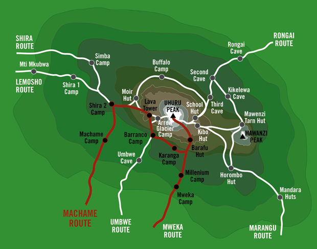
DAY 1: MACHAME GATE TO MACHAME CAMP
Hiking Time: 6-7 hrs
Total Distance: 18km / 11 miles
Starting Altitude: 1,490m/4,888ft
Final Altitude: 2,980m/9,776ft
Habitat: Montane (rain) Forest
After breakfast, it is approximately a 1 hour drive to the village of Machame. Depending on the condition of the road, it may be possible to drive 3km further from the village to the Machame gate of the Mt. Kilimanjaro National Park (1,815m). After registering at the gate office, you start your ascent and enter the lush rain forest. Here, you will listen to the sounds of many exotic birds, and may even see monkeys such as the black & white colobus – these monkeys are black with a long cape’ of white hair and a flowing white tail.
Most of today’s day is spent in the forested slopes of Mt. Kilimanjaro, most of which is considered to be rainforest zone. Rain is possible, the trail will most likely be soggy and muddy. You climb the lower slopes of the mountain, ending at the Machame Campsite, just beyond the rain forest and within the heath-land.
DAY 2: MACHAME CAMP TO SHIRA 2 CAMP
Hiking Time: 6-7 hrs
Total Distance: 9km/5.6 miles
Starting Altitude: 2,980m/9,776ft
Final Altitude: 3,840m/12,598ft
Habitat: Moorland
A steep climb through the heath land of savannah, and Giant Heather. You will reach a gentler ascent through the lower alpine moorland, which is notable for beautiful wild alpine flowers and the unique giant lobelia and giant groundsel (senecio kilimanjari) plants.
After a short lunch and rest, you will traverse across the Shira plateau west towards a river gorge, and finally reach the Shira campsite. The night at this exposed camp will be colder than the previous night, with temperatures dropping to well below freezing.
DAY 3: SHIRA 2 CAMP TO BARRANCO CAMP
Hiking Time: 7-8 hrs
Total Distance: 15km/9.3 miles
Starting Altitude: 3,840m/12,598ft
Final Altitude: 3,950m (via 4,630m) /12,959ft (via 15,190ft)
Habitat: Montane Semi-Desert
Today you turn east and continue to climb pole pole (slowly, slowly) through the rocky, barren terrain. Lunch will be served, then the ascend the rocky scree path to the Lava Tower (4,630m). The trek now starts to become more difficult, as the trail steepens, and most hikers start to feel the affects of the altitude, weakness and lack of breathe is common.
From the Lava Tower, the trail descends steeply for 2 hours down more than 600m into the Great Barranco Valley. This descent affords fantastic views and some great photo opportunities of the Western Breach and Breach Wall. Barranco Camp is set on a col (flat area) enclosed on three sides by the Breach Walls, and the Kibo massif itself. Hanging glaciers glint in the sunshine above, amidst the eerie landscape of plants such as the giant groundsels, and the uniquely endemic Giant Lobelia. This is definitely the toughest day so far, but incredibly beautiful.
DAY 4: BARRANCO CAMP TO KARANGA CAMP
Hiking Time: 4-5 hrs
Total Distance: 7km/4.4 miles
Starting Altitude: 3,950m/12,959ft
Final Altitude: 3,990m/13,090ft
Habitat: Alpine Desert
Today is the Great Barranco Wall, an imposing face above your camp. A steady climb up the eastern wall takes you just below the Heim Glacier, where you may have some awesome views of Kilimanjaro. The trail continues down into the Karanga Valley.
DAY 5: KARANGA TO BARAFU CAMP
Hiking Time: 4-5 hrs
Total Distance: 5km/3 miles
Starting Altitude: 3,990m/13,090ft
Final Altitude: 4,550m/14,927ft
Habitat: Alpine Desert
The trail climbs through an empty and dry landscape up to Barafu Camp. The two peaks Kibo and Mawenzi can been seen from camp. Barafu is the Swahili word for “ice”, and the camping area is on a ridge in an narrow and exposed flat area. Here there are ever-present gale winds that come off the mountain peaks.
In preparation for your final ascent the same night, you will familiarize yourself with the terrain before dark, and prepare your equipment and thermal clothing for the summit attempt. Sleep may be difficult, but you will lie down after dinner to rest for the 1,345m final ascent.
DAY 6: BARAFU CAMP TO SUMMIT TO MWEKA CAMP
Hiking Time: 7 hrs to summit, 7-8hrs descent
Total Distance: 7km/4.3 miles to summit, 23km/23 miles descent
Starting Altitude: 4,550m/14,927ft
Summit Altitude: 5895m/19,340ft Uhuru Peak
Final Altitude: 3,100m/10,170ft
Habitat: Alpine desert
Today you will be woken at approximately in time to leave camp by around 12am, and after a warm drink and a light snack, you will begin the most difficult though most rewarding day of the trek your hike up to the top of Africa. Climbing through the dark, you will ascend northwest on rough scree passing between the Rebmann and Tarzel glaciers. After approximately 6 hours of slow but strenuous hiking, you reach the rim of the main crater, Stella Point, at 5,685m. It is here where you will be rewarded with a breath-taking sunrise (weather permitting), and enjoy a short rest. From Stella Point the trail is usually snow-covered, and every step of the 3 hour ascent to Uhuru peak is challenging. At 5,895m, Uhuru, which means freedom in Swahili, is the highest point in Africa. Take a few minutes to appreciate your accomplishment, as this is day to remember for the rest of your life! The time you will spend on the summit will depend on the weather conditions; the temperatures range from just below freezing at midnight, to between -12 C to -23 C just before dawn. You will retrace your steps back down the same trail, and descend back to Barafu camp. Here you will have a well earned but short rest and collect the rest of your gear. Then head down the rock and scree path into the moorland zone, reaching the forest, and eventually arriving at Mweka hut in the late afternoon. Today is the longest, and the most mentally and physically challenging of the trek. But a day that will stay with you forever, as you conquered the heights of Kilimanjaro.
DAY 7: MWEKA CAMP TO MWEKA GATE TO MOSHI
Hiking Time: 4-5 hrs
Total Distance: 12km/7.45 miles
Starting Altitude: 3,100m/10,170ft
Final Altitude: 1,980m/6,496ft
Habitat: Montane Rain Forest
At a much lower altitude than the last few mornings, today you will wake up full of oxygen and ready to descend the short hike to the Mweka Gate. Enjoy the forest on the slopes of Mt. Kilimanjaro, and upon arrival at the Mweka gate, successful hikers will receive their summit certificates (gold for Uhuru Peale, Green for Stella point).
From the Mweka Gate you will continue down into the Mweka village for lunch, normally a muddy 1 hour hike. Upon arrival to Moshi in the afternoon, relax, or have that much-deserved shower and congratulatory beverage.