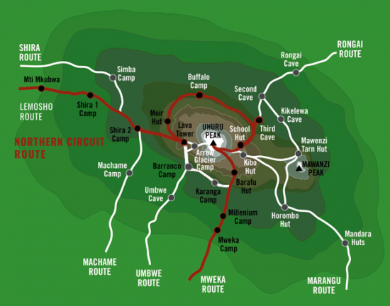
Northern Circuit Route
The Northern Circuit is the longest, most beautiful route that approaches from the West, circumnavigating Mount Kilimanjaro.
Considered one of the best trails on Kilimanjaro is the Northern Circuit Route, enjoy the rarely visited northern slopes and nearly 360 degrees of true mountain wilderness. This climb begins with a drive from Moshi to the Londorossi Gate, where you begin. The first two days are spent hiking through the rainforest to Shira Ridge, before crossing the Shira Plateau. The trail then heads north and circles clockwise from Moir Hut to Buffalo Camp to School Hut, and summits from the east. Descend is made via the Mweka route.
The Northern Circuit Route offers less climber traffic, has the most acclimatization time and the highest summit success rate.
The 9 day Northern Circuit Route is a recommended route.
DAY 1: LONDOROSSI GATE TO BIG TREE CAMP
Hiking Time: 3-4 hours
Total Distance: 7km/4 miles
Starting Elevation: 2,359m/7,742ft
Final Elevation 2,894m/9,498ft
Habitat: Rain Forest
You depart Moshi for Londorossi Gate, which takes about 2 hours, where you will complete entry formalities. Then drive another 45 minutes to the Lemosho trailhead. Here you will be begin hiking through undisturbed forest to the first camp site Mti Mkubwa (Big Tree).
DAY 2: MTI MKUBWA TO SHIRA 1 CAMP
Hiking Time: 5-6 hours
Total Distance: 8km/5 miles
Starting Elevation: 2,894m/9,498ft
Final Elevation 3,505m/11,500ft
Habitat: Health
The trail winds through the rainforest until it steepens slightly leading you to the moorland zone where you will get your first sight of Kibo. You will cross the Shira Ridge where the trail flattens as you reach Shira Camp 1 which is located next to a mountain stream on the Shira Plateau.
DAY 3: SHIRA 1 CAMP TO SHIRA 2 CAMP
Hiking Time: 3-4 hours
Total Distance: 10km/6 miles
Starting Elevation: 3,505m/11,500ft
Final Elevation 3,810m/12,500ft
Habitat: Health
Day three on the Northern Circuit Route is an easy walk across the Shira plateau that leads you to Shira Camp 2, located on the moorland meadows near a mountain stream. The heath zone displays abundant wildflowers and unique Senecio trees.
DAY 4: SHIRA 2 CAMP TO LAVA TOWER
Hiking Time: 4-5 hours
Total Distance: 7km/4 miles
Starting Elevation: 3,810m/12,500ft
Final Elevation: 4,629m/15,190ft
Habitat: Alpine Desert
Lava Tower to Moir Hut
Hiking Time: 2-3 hours
Distance: 7 km/4 miles
Starting Elevation: 4,629m/15,190ft
Final Elevation: 4,139m/13,580ft
Habitat: Alpine Desert
You continue to the east up a ridge and then southeast towards the Lava Tower – a 300 ft tall volcanic rock formation. Then head from the main trail to Moir Hut, there are a variety of walks are available here making this an excellent acclimatization opportunity. Shira Plateau is one of the highest plateaus on earth.
DAY 5: MOIR HUT TO BUFFALO CAMP
Hiking Time: 5-7 hours
Distance: 12 km/7 miles
Starting Elevation: 4,139m/13,580ft
Final Elevation: 4,023m/13,200ft
Habitat: Alpine Desert
You trek out of Moir Valley with a moderately steep climb, and hike to the summit of Lent Hills before returning to the main trail. The path crosses a rock field and the landscape rolls gently before reaching Buffalo Camp. This section of the trail offers great views across the plains that lie north of Kilimanjaro and stretch out to the Kenyan/Tanzanian border.
DAY 6: BUFFALO CAMP TO THIRD CAVE
Hiking Time: 5-7 hours
Distance: 8 km/5 miles
Starting Elevation: 4,023m/13,200ft
Final Elevation: 3,870m/13,700ft
Habitat: Heath
As you head up Buffalo Ridge, the terrain becomes increasingly sparse. This route is rarely travelled and you will enjoy the mountain wilderness feel. You trek through remote valleys on to the northern slopes of Kilimanjaro until arriving at Third Cave.
DAY 7: THIRD CAVE TO SCHOOL HUT
Hiking Time: 4-5 hours
Distance: 5 km/3 miles
Starting Elevation: 3,870m/13,700ft
Final Elevation: 4,754m/15,600ft
Habitat: Alpine Desert
The trails climbs steadily up and over the “Saddle,” between Kibo and Mawenzi continuing to camp, School Hut. Once here you will rest, enjoy an early dinner to prepare for the summit day.
DAY 8: SCHOOL HUT TO UHURU PEAK
Hiking Time: 6-8 hours
Starting Elevation: 4,754m/15,600ft
Final Elevation: 5,895m/19,341ft
Habitat: Artic
Uhuru Peak to Mweka Camp
Hiking Time: 4-6 hours
Distance: 12 km/7 miles
Starting Elevation: 5,895m/19,341ft
Final Elevation: 3,067m/10,065 ft
Habitat: Artic
Summit Night! You will be woken at around midnight, for tea and biscuits before setting off into the night and ascend over scree and rocks until you reach Gillman’s Point at the crater rim at dawn where you will rest briefly before continuing to the summit Uhuru Peak. This is the most challenging part of the trek for most climbers with the highest chance of suffering from altitude sickness. Take in the view from the summit and ensure you have taken plenty of photographs before starting your descent straight down to Mweka Hut camp site, stopping at Barafu for lunch. The trail is very rocky and can be quite hard on the knees. Mweka Camp is situated in the upper forest and mist or rain can be expected in the late afternoon. Later in the evening, we enjoy our last dinner on the mountain and a well-earned sleep.
DAY 9: MWEKA CAMP TO MWEKA GATE
Hiking Time: 3-4 hours
Distance: 10 km/6 miles
Starting Altitude: 3,067m/10,065ft
Final Altitude: 1,980m/6,496ft
Habitat: Rain Forest
At a much lower altitude than the last few mornings, today you will wake up full of oxygen and ready to descend the short hike to the Mweka Gate. Enjoy the forest on the slopes of Mt. Kilimanjaro, and upon arrival at the Mweka gate, successful hikers will receive their summit certificates (gold for Uhuru Peak, Green for Stella Point).
From the Mweka Gate you will continue down into the Mweka village for lunch, normally a muddy 1 hour hike. Upon arrival to Moshi in the afternoon, relax, or have that much-deserved shower and congratulatory beverage.