Kilimanjaro’s Geology
Mount Kilimanjaro is one of the largest stratovolcanoes in the world. A stratovolcano is formed by a series of layers of ash and lava laid on top of each other as a volcano goes through different eruptive phases. It is also known as a composite volcano comprising numerous layers of lava, tephra (cinder) and volcanic ash.
Kilimanjaro is the world’s highest free standing, snow-covered equatorial mountain. It is the highest mountain in Africa, rising 5,895 meters (19,340 feet) and covers an area of about 388,500 hectares. It stands alone and is the largest of an east-west belt of volcanoes across northern Tanzania.
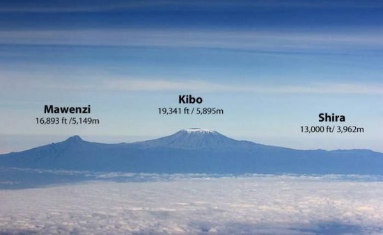
Kilimanjaro has three main volcanic peaks of varying ages lying on an east-southeast axis.
To the west, the oldest peak Shira (3,962 m/12,998 ft) of which only the western and southern rims remain, is a relatively flat upland plateau of some 6,200 hectares. About one million years ago molten lava started to burst through the fractured surface of the Rift Valley at the location of Kilimanjaro. The initial lava flows were thin and low viscous magma. Because of this the lava spread out and created a gently sloping base for Kilimanjaro. Over time the lava become cooler and more viscous. The huge pressures behind the eruption pushed part of the Earth’s crust skywards, creating the Shira volcano, the oldest of the volcanoes forming the Kilimanjaro massif. Around 500,000 years ago Shira ceased erupting and collapsed forming the Shira Plateau.
The rugged peak of Mawenzi (5,149 m/16,893 ft) lies to the east. The volcano known as Mawenzi formed as a result of another eruption within the Shira caldera. Mawenzi has eroded over the last millennia but has kept some of its volcanic shape. The top of its western face is fairly steep with many crags, pinnacles and dyke swarms. Its eastern side falls in cliffs over 1,000 m (3,280 ft) high in a complex of gullies and rock faces, rising above two deep gorges, the Great Barranco and the Lesser Barranco.
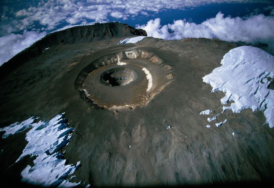
Kibo (5,895 m/19,340 ft) is the most recent summit, having last been active in the Pleistocene. Around 460,000 years ago, a massive eruption barely west of Mawenzi produced Kibo. Continual subterranean pressure forced the earth’s crust even higher and caused Kibo to erupt several more times. This forced the summit ever higher until reaching a maximum height of about 5,900 m (19,356 ft).
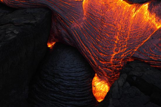
A further huge eruption from Kibo 100,000 years later led to the formation of Kilimanjaro’s characteristic shiny black stone – which in reality is just solidified black lava, or obsidian. This spilled over from Kibo’s crater into the Shira caldera and around to the base of the Mawenzi peak, forming the so-called Saddle. Later eruptions created a series of distinctive mini-cones, or parasitic cones, that run in a chain south-east and north-west across the mountain, as well as the smaller Reusch Crater inside the main Kibo summit.
The last volcanic activity of note, just over 200 years ago, left a symmetrical inverted cone of ash in the Reusch Crater, known as the Ash Pit, that can still be seen today. It consists of two concentric craters of 1.9 x 2.7 kilometers (km) and 1.3 km in diameter with a 350 m (1,148 ft) deep ash pit in the center. Between Kibo and Mawenzi there is a plateau of some 3600 hectares, called the Saddle, which forms the largest area of high altitude tundra in tropical Africa. There are deep radial valleys especially on the western and southern slopes.
The mountain is a combination of both shield and volcanic eruptive structures. Over time different flows have produced a variety of different rock types. The predominant rock types on Shira and Mawenzi are trachybasalts; the later lava flows on Kibo show a gradual change from trachyandesite to nephelinite. There is also a number of intrusions such as the massive radial and concentric dyke-swarms on Mawenzi and the Shira Ridge and groups of nearly 250 parasitic cones chiefly formed from cinder and ash.
Since 1912, the mountain has lost 82% of its ice cap and since 1962, 55% of its remaining glaciers. Kibo still retains permanent ice and snow and Mawenzi also has patches of semi-permanent ice, but the mountain is forecast to lose its ice cap in 2030. Evidence of past glaciation is present on all three peaks. The mountain remains a critical water catchment for both Kenya and Tanzania but as a result of the receding ice cap and deforestation, several rivers have dried up, affecting the forests and farmland below.