Facts about Kilimanjaro
Altitude and Size
Geography/Location
- Mount Kilimanjaro is located in Tanzania in east Africa, in the north of the country, near the border between Tanzania and Kenya.
- The whole area lies between 2° 45′ to 3° 25’S and 37° 00′ to 37° 43’E (not far south of the equator).
Population
- The area surrounding Kilimanjaro is heavily populated.
- The local tribe living in the foothills is the Chagga. The Chagga arrived about 300 years ago as nomads and settled as farmers, terracing Kilimanjaro’s slopes.
- There are 18 larger “forest villages” in the forest reserve that surrounds Kilimanjaro National Park.
- Villagers use the forest (illegally) for firewood, farming, beekeeping, hunting, charcoal production and logging.
Geology
- Kilimanjaro is a giant stratovolcano.
- Kilimanjaro is classified as dormant, not extinct.
- It is the largest of an east-west belt of volcanoes across northern Tanzania.
- Kilimanjaro started forming about 750,000 years ago.
- Three main volcanic peaks (Shira, Mawenzi and Kibo) and a number of smaller parasitic cones.
- Shira is the oldest peak, Kibo the youngest.
- Kibo’s last major eruption occured about 360,000 years ago.
- The last volcanic activity was recorded just over 200 years ago and resulted in today’s ash pit.
- Kibo has two concentric craters, 1.9 x 2.7 km and 1.3 km in diameter, respectively.
- The central ash pit is 350 m deep.
- Uhuru Peak on the southern rim of the outer crater is the highest point on the mountain.
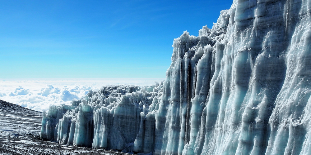
- Since 1912 Kilimanjaro has lost 82% of its ice cap.
- Since 1962 Kilimanjaro has lost 55% of the remaining glaciers.
- This may be local evidence of climate warming but may also be due to the loss of humidity caused by deforestation and clearing for farms.
- Today, the total glacier area is about 2.5 km2.
- The latest forecasts predict that Kilimanjaro may lose the plateau ice within the next 30-40 years, but the slope glaciers may remain much longer.
Climate
- There are two wet seasons, November to December and March to May.
- The driest months are August to October.
- Rainfall decreases rapidly with altitude.
- 96% of all rain on Kilimanjaro falls below 3000m.
- The average yearly rainfall at Marangu Gate (start of Marangu route) is 2300mm.
- Above 4500 m the conditions are desert like.
- The average yearly rainfall at Kibo Huts (highest hut on Marangu route) is less than 200mm.
- The northern side of the mountain is a lot drier than the southern side.
- January to March are the warmest months.
Vegetation Zones
- The mountain has five main vegetation zones:
- Savanna bushland (700-1000m on southern side and 1400-1600m on northern side),
- Sub-montane agro-forest (the densely populated farmlands to the south and south east)
- Montane forest belt (the rainforest, from 1300m to 2800m on southern side, above 1600m on drier northern side)
- Sub-alpine moorland and alpine bogs (the heath and moorland, 2800-4000m)
- Above this is the alpine desert.
Animals
- 140 species of mammals (87 forest species) live on Kilimanjaro. Species include 7 primates, 25 carnivores, 25 antelopes and 24 species of bat.
- At least seven larger mammal species have been recorded above the tree line: Kilimanjaro tree hyrax, grey duiker, red duiker, eland, bushbuck, buffalo and elephants.
- Three primate species live in the montane forests: blue monkey, black and white colobus, Colobus and bushbaby.
- 179 species of birds have been recorded.
Kilimanjaro National Park
- Size of the national park: 75, 353 hectares
- Size of the surrounding forest reserve: 107,828 hectares
- Mt Kilimanjaro and its forests were declared a game reserve in 1910 by the German colonial government.
- In 1921 the area was gazetted as a Forest Reserve and in 1973 the mountain above the tree line (2700m) was reclassified as a national park.
- The national park also protects some of the montane forest, and six access corridors through the forest belt below.
- Kilimanjaro National Park was opened for public access in 1977.
- In 1987 the park was inscribed as a World Heritage Site for its natural value.
- The park is administered by the Tanzania National Parks Authority.
- The area lies at 2°45′-3°25’S, 37°00′-37°43’E.